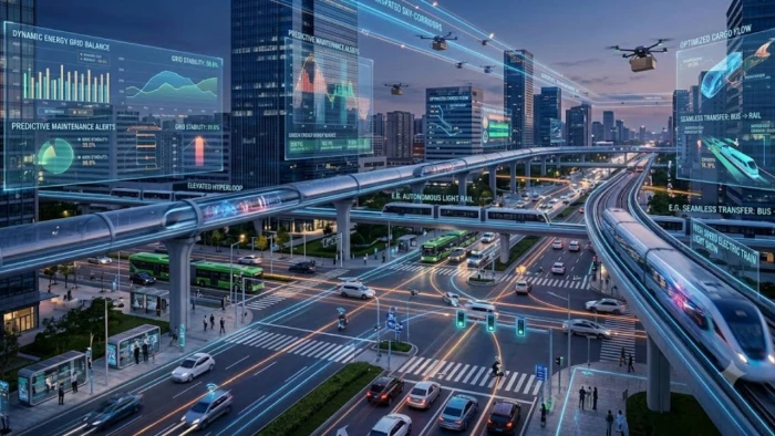
Artificial intelligence is beginning to influence entire transportation networks—not just the vehicles operating within them. New federal guidance points toward roads where cameras detect near misses, connected vehicles report dangerous braking patterns, traffic signals respond to changing conditions, and infrastructure warns drivers about queues, weather and unseen hazards.
For much of the past decade, conversations about artificial intelligence in transportation have centered on one ambitious objective: creating a vehicle capable of driving itself.
That goal remains important, but it represents only one part of a much larger technology shift.
The more immediate transformation is taking place outside the vehicle. Transportation agencies are beginning to combine roadside sensors, connected-vehicle data, video analytics, cloud platforms, edge computing and real-time communications to understand what is happening across an entire road network.
Instead of relying on one car to identify every risk independently, the surrounding infrastructure can collect information from thousands of sources, analyze emerging conditions and distribute warnings to vehicles, traffic operators and emergency responders.
This network-level approach is reflected in the U.S. Department of Transportation’s updated intelligent transportation systems guidance, published March 27, 2026. The guidance identifies potential applications including AI-assisted traffic conflict analysis, connected-vehicle hard-braking data, automatic incident detection, queue warnings, road-weather alerts, intelligent signals and infrastructure that communicates hazards or signal timing directly to vehicles.
The result is a broader definition of transportation intelligence. The future may not depend solely on when fully autonomous vehicles become common. It may depend just as much on whether roads, signals, vehicles and transportation agencies can exchange reliable information quickly enough to prevent dangerous situations.
An autonomous vehicle generally uses onboard cameras, radar, lidar, maps and computing systems to understand its immediate environment. A networked transportation system operates at a different scale.
It can observe conditions beyond the line of sight of an individual driver or vehicle. A roadside camera may identify a pedestrian hidden behind a parked truck. Connected cars may reveal a cluster of hard-braking events several miles ahead. Weather sensors may detect deteriorating pavement conditions, while a traffic-management platform predicts that a queue is forming behind a work zone.
The intelligence comes from combining these signals rather than treating each one separately.
| Transportation intelligence layer | Typical data or technology | Potential response |
|---|---|---|
| Vehicle layer | Speed, location, braking, acceleration and onboard safety messages | Warn drivers about sudden braking, collisions or unsafe speeds |
| Infrastructure layer | Traffic signals, cameras, radar, thermal sensors and roadside units | Detect pedestrians, modify signal timing or broadcast hazards |
| Network layer | Historical crashes, probe-vehicle data, weather and congestion patterns | Identify high-risk corridors and predict emerging incidents |
| Operations layer | Traffic-management centers, emergency systems and maintenance platforms | Divert traffic, dispatch responders or adjust corridor operations |
| Traveler layer | Navigation apps, dashboards and in-vehicle displays | Deliver personalized warnings, routing advice and road-condition updates |
This architecture does not require every vehicle to be autonomous. Human-driven cars, buses, freight vehicles, emergency vehicles, snowplows, smartphones and roadside equipment can all participate at different levels.
That is what makes network-based transportation technology potentially more deployable in the near term. It can provide useful information to today’s mixed fleet while also creating infrastructure that future automated vehicles may use.
The case for smarter transportation infrastructure begins with the scale of roadway risk.
The National Highway Traffic Safety Administration estimates that 36,640 people died in U.S. traffic crashes during 2025. That was a 6.7% decline from 2024, while the fatality rate fell to 1.10 deaths per 100 million vehicle miles traveled. Although the improvement is significant, more than 100 people still died on an average day.
Weather creates another substantial area of risk. Federal Highway Administration data based on 2019–2023 averages shows approximately 744,911 weather-related crashes annually, resulting in about 268,239 injuries and 3,807 deaths. Rain or mist was present in more than three-quarters of weather-related crashes.
These numbers help explain why transportation agencies are looking beyond conventional crash reports. A crash report describes an event after it has occurred. Connected and sensor-based systems can also capture near misses, hard braking, sudden speed changes, vehicle trajectories and environmental conditions before those signals become a serious collision.
| Indicator or deployment result | Reported figure | Why it matters |
| Estimated U.S. traffic deaths in 2025 | 36,640 | Shows the continuing scale of the roadway-safety challenge |
| Average annual weather-related crashes | 744,911 | Supports the need for real-time road-weather detection and warnings |
| Federal funding for major V2X deployments in Arizona, Texas and Utah | Nearly $60 million | Signals movement from small trials toward larger regional deployments |
| Reduction in hard-braking events in an Indiana queue-warning pilot | Approximately 80% | Suggests that connected warnings can influence drivers before they reach a hazard |
| Reduction in forward-collision conflicts in a Tampa V2X pilot | 9% | Offers early evidence of safety benefits while showing that results may be incremental |
| School-zone speed-limit compliance in a Columbus deployment | Increased from 18% to 56% | Demonstrates how connected warnings can change driver behavior without autonomous control |
Pilot results should not be treated as guaranteed outcomes for every city or roadway. Traffic patterns, driver behavior, communications coverage and system design vary considerably. However, these deployments provide evidence that useful safety improvements can occur without waiting for universal self-driving capability.
Traditional road-safety planning relies heavily on reported crashes. That approach has an unavoidable weakness: agencies may need several severe incidents before a location appears statistically dangerous.
Traffic conflict analysis attempts to identify risk earlier.
Computer-vision systems can examine video from intersections or corridors and reconstruct the movement of vehicles, cyclists and pedestrians. Instead of recording only collisions, the software can detect interactions in which road users come dangerously close, brake suddenly or take evasive action.
The Department of Transportation’s 2026 guidance describes both passive and active uses of this technology. Passive analysis can identify recurring conflict locations for road-safety audits and infrastructure planning. Active systems can analyze trajectories in real time and issue warnings when road users appear to be moving toward a collision.
This changes the unit of analysis from “Where have crashes already happened?” to “Where are dangerous interactions repeatedly occurring?”
For transportation planners, that distinction matters. Near-miss data may reveal problems with turning movements, crosswalk visibility, signal timing or lane design before the crash history becomes severe enough to justify conventional intervention.
The technology nevertheless requires careful validation. Camera angle, lighting, weather, occlusion and unusual road-user behavior can affect model accuracy. A system designed to influence signal timing or send immediate warnings must be tested more rigorously than one used for retrospective planning.
Connected vehicles generate behavioral information that conventional road sensors may miss. Hard-braking events are one example.
A single sudden stop may not indicate much. A concentration of hard-braking events at the same curve, intersection or work-zone approach can point to a recurring problem. When combined with vehicle speed, traffic volume, weather records and historical incident data, braking patterns can help agencies identify locations where drivers are routinely encountering unexpected conditions.
The Department of Transportation specifically identifies connected and automated vehicle hard-braking data as a possible input for predicting high-risk incident locations. Its guidance also recommends combining vehicle information with weather, historical traffic and incident datasets rather than evaluating each source independently.
Indiana offers one practical example. During a 26-month pilot, the state deployed 53 connected queue-warning trucks ahead of interstate work zones. The trucks broadcast digital alerts to navigation systems, helping drivers recognize an approaching queue before they reached it. According to the federal ITS evaluation, vehicle speeds began declining roughly 1,500 to 2,000 feet before the trucks, while hard-braking events fell by approximately 80%.
The important technology lesson is not simply that drivers received an alert. The system closed a data loop:
A hazard was detected, its location was converted into structured information, the warning was distributed through a digital network, and driver behavior was measured afterward.
That feedback loop is what allows an intelligent transportation system to improve over time.
Vehicle-to-everything, or V2X, communication allows vehicles and wireless devices to exchange safety information with other vehicles and roadside infrastructure.
Its most valuable applications may involve situations in which onboard sensors have an incomplete view. A vehicle approaching an intersection may not see an emergency vehicle coming from a side street. A driver may not know that traffic has stopped around a curve. A cyclist or pedestrian may be blocked from view by another vehicle.
Roadside sensors can detect the risk and send a warning before the two road users become visible to one another.
The Department of Transportation released a national V2X deployment plan in August 2024, describing a system in which vehicles, wireless devices and roadside infrastructure communicate to improve safety, mobility and efficiency. The plan also emphasizes interoperability, privacy, consumer protection and secure communication across platforms.
Federal investment is beginning to reflect that network model. Nearly $60 million was awarded to V2X projects in Arizona, Texas and Utah. Arizona’s project includes 750 physical and virtual roadside units connected to an estimated 400 onboard units, supporting applications such as emergency-vehicle preemption, vulnerable-road-user detection and signal priority. Texas is deploying technology across Greater Houston and College Station, while Utah’s project extends into Colorado and Wyoming and includes connected intersections, weather warnings, curve-speed alerts and traveler information.
These projects are not simply autonomous-vehicle test beds. They are regional communications platforms intended to support buses, emergency responders, freight fleets, road workers, pedestrians and ordinary motorists.
Traffic lights have traditionally operated through fixed schedules, vehicle detectors or relatively simple adaptive controls. Connected infrastructure adds another layer: signals can receive information about who is approaching and why priority may be needed.
A signal may extend green time for a bus running behind schedule, clear an intersection for an ambulance or reduce unnecessary stopping by a snowplow. The decision can be based on vehicle identity, route, traffic demand and surrounding safety conditions.
The DOT’s latest ITS guidance identifies emergency-vehicle preemption, transit signal priority and intelligent traffic signals as among the most commonly deployed or planned connected-vehicle applications. It also describes infrastructure capable of sharing signal phase and timing information directly with vehicles.
Real deployments show that the benefits can extend beyond travel time. In Fulton County, Georgia, two school buses used cellular V2X communications with roadside units at 62 signalized intersections. The federal evaluation reported 40% fewer stops, a 13% reduction in travel time and more than a 7% decrease in fuel consumption.
Utah tested a related approach with connected snowplows. Signal preemption reduced unnecessary stops and helped vehicles move through equipped corridors more consistently. The evaluation found stronger reductions in crash rates on equipped routes than on comparison routes, although the report also noted that some operational evidence was anecdotal and should therefore be interpreted carefully.
Weather intelligence for transportation is more specific than a general forecast.
A transportation agency needs to know whether pavement is freezing on a particular bridge, visibility is deteriorating along a specific corridor, water is covering a low-lying road or braking behavior suggests that drivers are encountering unexpected surface conditions.
An intelligent road-weather platform can combine atmospheric forecasts with pavement sensors, connected-vehicle information, camera feeds, maintenance reports and traffic speeds. It can then deliver different actions to different users.
Drivers may receive a warning to slow down. Traffic operators may lower a variable speed limit. Maintenance teams may prioritize treatment of a bridge deck. Navigation systems may route vehicles away from flooding, while freight operators receive corridor-specific delay information.
The 2026 DOT guidance explicitly includes road-weather information and management systems that collect local conditions and alert drivers to reduce speed or change routes. It also identifies connected snowplows and signal priority as examples of infrastructure responding to operational needs rather than merely displaying information.
Given that adverse atmospheric conditions are associated with about 12% of U.S. crashes, road-weather intelligence is not a niche application. It is one of the clearest examples of why network-level awareness can be more useful than asking every vehicle to interpret conditions independently.
A transportation prediction system is only as useful as the information it receives.
State agencies, cities, mapping providers, vehicle manufacturers, emergency services and infrastructure operators often use different data formats. Without common standards, a work-zone closure recorded by one agency may not reach the navigation system being used by an approaching driver.
The Federal Highway Administration’s Connected Corridors initiative focuses on this less visible part of the technology stack. It promotes shared standards for work zones, incidents, weather and special events so transportation systems can exchange trusted, real-time information across jurisdictions. FHWA reports that 35 states are publishing standardized work-zone data using Connected Work Zone and Work Zone Data Exchange specifications.
This is an important distinction for technology leaders. Transportation intelligence is not primarily a model-procurement project. It is a systems-integration project involving data quality, communications infrastructure, cybersecurity, governance, application programming interfaces and operational responsibility.
A sophisticated prediction model cannot compensate for outdated lane-closure information, inconsistent timestamps or a roadside unit that is no longer maintained.
| Decision area | Questions agencies and technology leaders should ask |
| Data quality | Are location, timing, weather and vehicle observations accurate enough for the intended decision? |
| Model validation | Has the system been tested on the local road geometry, traffic mix, lighting and seasonal conditions? |
| False alerts | Could excessive or low-value warnings cause drivers or operators to ignore future notifications? |
| Interoperability | Can vehicles, roadside equipment, traffic platforms and third-party applications exchange information consistently? |
| Cybersecurity | How are devices authenticated, software updated and false safety messages detected? |
| Privacy | Is personally identifiable or traceable travel information necessary, and how long will it be retained? |
| Human oversight | Which actions can be automated, and which should remain under traffic-operator control? |
| Maintenance | Who is responsible when cameras, sensors, communications links or data feeds stop working? |
| Measurement | Will success be judged by crashes, near misses, hard braking, response time, travel reliability or another defined outcome? |
Transportation systems operate in safety-critical environments, so the acceptable error rate depends on the application.
A retrospective model that ranks intersections for further study can tolerate more uncertainty than a system that changes a traffic signal or issues an immediate collision warning. Agencies should match governance, testing and human oversight to the potential consequence of an incorrect decision.
They should also distinguish between prediction and proof. A model may identify a location as high risk, but transportation engineers still need to determine whether the underlying cause is road geometry, visibility, speed, driver behavior, signal timing or another factor.
Autonomous vehicles attempt to make an individual machine more capable. Networked transportation systems try to make the environment more informative.
The two approaches are complementary. Automated vehicles may eventually use V2X warnings, signal-timing information and digital work-zone data to operate more safely. At the same time, human drivers can benefit from the same infrastructure long before full automation becomes widespread.
This is why the future of transportation AI is bigger than autonomous vehicles.
The most consequential systems may be the ones that drivers barely notice: a warning delivered before an unseen queue, a signal that gives an ambulance a clear path, a camera that identifies a dangerous near-miss pattern or a weather platform that slows traffic before a bridge freezes.
None of these applications requires a car to drive itself. They require vehicles, infrastructure and public agencies to share information reliably enough to make better decisions.
That may prove to be the more practical path toward intelligent transportation—not replacing every driver, but giving the entire road network a clearer view of what is about to happen.
Share your thoughts about this article.
Be the first to post a comment!
Quick answerBlackbox AI is an AI coding assistant used for generating code, debu...
Harpreet Singh1 day ago
I did not set out to write a warning. I set out to find a cheap, fast tool that...
Nitin2 days ago

Job hunting in 2026 feels like a part-time job you never applied for. You refres...
Deepak Mehra4 days ago

You-TLDR is useful when you do not want to sit through a full YouTube video just...
Harpreet Singh4 days ago

Type "openfuture ai" into Google and you will find a strange mix of results. Hal...
Sakshi Dhingra4 days ago

Every week someone asks me the same thing. Should I keep paying for Quizlet, or...
Harpreet Singh5 days ago